BC witness Posted September 3, 2014 Author Posted September 3, 2014 Incorrigble1, I've seen gorgeous pictures of the "Big Sky" open country that blew me away, so don't sell your home turf short. I've spent some time in the wide open farm country/oil sands region of Northern Alberta, and seen dramatic landscapes there, as well, but it doesn't take me long to start missing the mountains. The view out my front window is a 10,000'+ volcano, and it's hard to leave that behind. The fact that it's in your country doesn't detract from its dramatic beauty at all.
Wingman1 Posted September 3, 2014 Posted September 3, 2014 Absolutely beautiful photos BC, I'll bet you and your son had a great time. Keep searching and the best of luck to you.
daveedoe Posted September 4, 2014 Posted September 4, 2014 thanks BC for the beautiful photo's. I have the same issues around the areas I used to play, roads blocked or gated, forest replanted and grown for 10, 20, 30 years just doesn't look the same. Land marks are hidden, thank goodness for a compass, Google earth and maps. Keep the pictures and reports coming, I love seeing them.
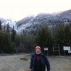
BC witness Posted September 8, 2014 Author Posted September 8, 2014 (edited) Since we have chosen to write off our earlier research area as a "dead zone' for the present, Thomas, Magniaesir, and I decided to scout another nearby creek valley this afternoon, one with a long history of sightings, including the famous Ruby Creek "home invasion" of 1941, and a sighting by a bear hunter as recently as 2008, which was investigated by Thomas, who found and cast a large footprint in the mud near the sighting.We knew that there was a major power transmission line being built through this valley, and across many others in the region, as well, and wanted to see how much of the valley was affected by the construction. We were only 2.5km up the logging road when we got the first clue; 5 large trucks from the utility company came rumbling through in convoy, raising huge clouds of dust, on Sunday afternoon! The lead truck stopped, and asked us to let the others clear before proceeding, which we did, and let us know that they were the last outbound for the day. We continued on to the site of the hunter's report to Thomas, which Thomas said had changed dramatically since that time, as the electric company had filled several acres of a swampy area, to build a large capacitor station,almost on top of the incedent location.The rest of the day was spent following the roads deeper into the valley, until we reached a high point that gave us a good view of the whole upper end of the watershed, from which we could glass a large area of clearcuts and the powerline right of way, so we stopped to stretch our legs, check the topo map, and let Thomas load his pipe for a good smoke.We found no sign at all, and think there's too much construction and logging activity right now to devote more time here, so it's on to the next area next weekend. Since we have chosen to write off our earlier research area as a "dead zone' for the present, Thomas, Magniaesir, and I decided to scout another nearby creek valley this afternoon, one with a long history of sightings, including the famous Ruby Creek "home invasion" of 1941, and a sighting by a bear hunter as recently as 2008, which was investigated by Thomas, who found and cast a large footprint in the mud near the sighting.We knew that there was a major power transmission line being built through this valley, and across many others in the region, as well, and wanted to see how much of the valley was affected by the construction. We were only 2.5km up the logging road when we got the first clue; 5 large trucks from the utility company came rumbling through in convoy, raising huge clouds of dust, on Sunday afternoon! The lead truck stopped, and asked us to let the others clear before proceeding, which we did, and let us know that they were the last outbound for the day. We continued on to the site of the hunter's report to Thomas, which Thomas said had changed dramatically since that time, as the electric company had filled several acres of a swampy area, to build a large capacitor station,almost on top of the incedent location.The rest of the day was spent following the roads deeper into the valley, until we reached a high point that gave us a good view of the whole upper end of the watershed, from which we could glass a large area of clearcuts and the powerline right of way, so we stopped to stretch our legs, check the topo map, and let Thomas load his pipe for a good smoke.We found no sign at all, and think there's too much construction and logging activity right now to devote more time here, so it's on to the next area next weekend. #1 Hunter Mt., across the Fraser River to the south of Ruby Creek. The River is hidden in the bottom of the valley below, from this angle. #2 Upper end of Ruby Creek valley - Harrison Lake is over the ridge to the left. #3 Thomas with his pipe, and Magniaesir studying the map on the hood of my "Blue Bigfoot Bus" Edited September 8, 2014 by BC witness
Guest Posted September 8, 2014 Posted September 8, 2014 Thanks, BC! Wondering if in #3....behind the guys in the distance,...is that a natural clearing on the slope - upper left corner of pic or results of logging or the Utility Co's work? Just curious!
BC witness Posted September 8, 2014 Author Posted September 8, 2014 HWM, all of the clearings in that photo are 2nd growth logging clearcuts, except the one I'm parked in, which is a heli landing pad. In #2, you can see the twin paths of the existing powerlines up the valley, but #1 does show natural openings across the valley where it's too rocky for trees.
BC witness Posted September 8, 2014 Author Posted September 8, 2014 Here are the links to the incidents at Ruby Creek as posted by magniaesir in another forum: http://www.bigfootencounters.com/classics/ruby.htmThis happened on property south of Lougheed Highway while we traveled north of the highwayhttp://grandcherokee.proboards.com/thre ... k-incidenthere is the 2008 report that BCWITNESS mentionedAs we don't plan on returning there in the foreseeable future we don't mind posting linksBoth of these incidents are featured in the show Bigfoot the definitive guide
Guest Posted September 14, 2014 Posted September 14, 2014 Enjoyed all of your posts and pics. A few years ago, I was in your beautiful country and did some squatching and hiking. However, me and my buddy had difficulty finding the Harrison Lake trail that you possiblly allude to that is just outside Harrison Hot Springs. We ended up hiking in circle. But, we had a great hour plus talk with John Green who is such a distinguished and honorable person. On Vancouver Island (near Crofton), my friend and I had a large rock tossed at our feet, followed by a tree being either snapped or broken a few minutes later. Absolute quiet in the forest all during the before, during and after of this encounter. While my friend went to find some other squatchers on the expedition, he left me alone that left me feeling quite vulnerable. I stood and talked to the gentle giant if he was still around, explaining my respect in passive mode. Nothing else happened. Two areas we also explored that appeared good for squatching were Strathcona National Park (day hike on trails that started at the ski resort) as well as the isolated Woss Lake where we camped overnight at beach in middle of lake. While we did not have any squatch activity, we saw cougar tracks. The nice lady that cared for the Lake on behalf of the Park Service strongly recommended that we do not hike to small lake at opposite side of the lake (approx 2 miles - we did not hike to it) since another couple had reported seeing a grizzly bear and scared them off on the bushwack / creek trail to the smaller lake. It makes me wonder whether it was a grizzly or a squatch. Going squatching in Southern IL on a couple of trips over next few weeks. Surprisingly, I have had some interesting Class B events in this area with several Class A sightings among the privately owned rural farms. Recently returned from Grand Tetons where the huckleberries were out in force too. I used them in my cereal though the pie is sounding really good now. Good luck out there! Jay
the parkie Posted September 16, 2014 Posted September 16, 2014 Thanks for the updates in this thread, thank you all and keep them coming.
BC witness Posted September 22, 2014 Author Posted September 22, 2014 The group managed another outing this month, on the first day of fall, which felt like the middle of summer, with bright sunshine, and temperature at 29C most of the afternoon. We chose to check out a valley near the east end of the Fraser Valley, south of Hwy 1. The start of the FSR is a little obscure, but we managed to locate it, and found the road to be in decent shape, as there is some active logging ongoing at the extreme end of one of the branch roads. The road climbs steeply for almost all of its 11km length, with a number of clearcuts in various stages of regrowth along the way, eventually ending at the present logging operation, near the crest of the eastern ridge of the drainage, at a spectacular lookout area with a view of most of the watershed.With the soil still damp from rain earlier in the week, we hads hopes of spotting tracks, but that didn't happen.We drove back down the valley, and back on to HWY 1, past Hope to the site of a report from about 2000, to have a look around. The site is already quite overgrown, compared to its open state at the time of the incedent. On another side trip along one of the valleys south of the highway, we found a very nice campsite, and a member of the group is planning a late fall campout there.It was wonderful to get out "on the hunt" for the day, see some new terrain, and spend time with friends and family who enjoy the search. A nice late afternoon lunch in Hope topped the day off, and the drive home went so smoothly, that the youngest member of the party (15) managed a good nap on the way. Some shots from the day: #1 End of the road at the logging site. #2 Looking south from there. #3 A side creek to the west #4 Looking for tracks in the sandy soil here - only found tracks from 1 moose, and lots of people. #5 Great campsite for a future basecamp. 1
hiflier Posted September 24, 2014 Posted September 24, 2014 (edited) Hello BC Witness and All, Just got back from a two week, sleeping in a tent, outing with my spouse and Golden Retriever. It takes a bit to pack for a trip like that and then unpack at the end of it but for a two week stay it's more than worth it! I do enjoy this thread and seeing what folks are up to and where they're going and thought I'd contribute a bit from this last excursion It's really hard to get better than this. A slice of paradise if you ask me: This happened on the second morning at breakfast: A good shot of the boy: Our view from the dinner table: The next door neighbor: A view of the camp from the canoe: Waking up. A scene that just may outweigh the morning coffee.....almost : On Oct 3rd I will be on a two day visit to some true Maine habitat suitable for supporting Bigfoot and I'll post pics from that adventure as well. Edited September 24, 2014 by hiflier
BC witness Posted September 24, 2014 Author Posted September 24, 2014 hiflier, it looks like you had a wonderful 2 weeks of decompression time. Thanks for the post and the great photos. I'm heading out tomorrow for 5 days in the mountains with an old buddy, and really looking forward to to disconnect from day to day life. I'm sure I'll have some pics when I get back.
hiflier Posted September 24, 2014 Posted September 24, 2014 (edited) Hello BC Witness, Decompression is a good word for it and it worked. I feel like a million bucks. The real difference for my spouse and I this year as opposed to the past 10 was that for the first time there was no angst because of returning to a job since we are now both retired. That alone seemed to stretch the time further and the our ability to enjoy the getaway even moreso and on a completely different level if that's even possible. Be safe out there and look forward to more photos of your gorgeous area. Edited September 24, 2014 by hiflier
daveedoe Posted September 24, 2014 Posted September 24, 2014 Beautiful setting hiflier. Is that body of water tidal? tidal was my first though because it looks so much like areas around the Puget Sound. After seeing the deer I figured it probably fresh water. Looking forward to more field trips, keep em coming.
Recommended Posts