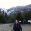
BC witness Posted April 22 Author Share Posted April 22 Looks like you had better weather than I did, a 100km or so WNW of you. I saw a few sunny breaks, but mostly drizzle all day, with a bit of fresh snow showing higher in the mountains, when I could see them. I heard earlier in the week that the Ross Lake road system had finally re-opened after being severely damaged in the major flood event we had in Nov. of '21, so of course I had to go check it out. There were several sections of a km or more that had been completely obliterated by the Silver Creek, in the north section, and the Skagit River in the southern stretch. They've done a good job of rebuilding the damaged sections, raising and realigning the roadbed and putting huge box culverts under the cross creeks, with lots of boulder riprap to reinforce the banks. Hopefully it will withstand future 100 year rainfall events. The gravel surface was in excellent shape, making it easy to maintain the 60km/hr speed limit, with only very minor washboards in a few sections. Most of the side trails were still accessible, so I explored as many as I had time for, as far as conditions allowed, getting stopped by washouts, deadfalls and landslides on all of them eventually. One of our group's favourite camp spots is still in good shape, so we'll probably do our usual summer outing there this year. As far as wildlife goes, I was disappointed to see only 1 grouse, and no larger game at all, though that valley is known to have deer, bear, cougar, bobcat, and moose, as well as several Sasquatch sightings that we've followed up on in the past. The valley bottom is prime game habitat, with many small creeks flowing down from the mountains on each side, and willow swamps and cattail bogs adjacent to the rivers and creeks. 2 Link to comment Share on other sites More sharing options...
BC witness Posted April 22 Author Share Posted April 22 More photos 2 Link to comment Share on other sites More sharing options...
MagniAesir Posted April 22 Share Posted April 22 Hopefully when I get back from Quebec, we can head out Link to comment Share on other sites More sharing options...
cmknight Posted April 22 Share Posted April 22 Pm me where that flat cleared spot is. I just might want to take my Astrophotography gear up there. Link to comment Share on other sites More sharing options...
BC witness Posted April 22 Author Share Posted April 22 1 hour ago, MagniAesir said: Hopefully when I get back from Quebec, we can head out Looking forward to it! Link to comment Share on other sites More sharing options...
BC witness Posted April 22 Author Share Posted April 22 1 hour ago, cmknight said: Pm me where that flat cleared spot is. I just might want to take my Astrophotography gear up there. Done Link to comment Share on other sites More sharing options...
BC witness Posted Sunday at 08:12 PM Author Share Posted Sunday at 08:12 PM Here's a 10 minute video of the Skagit Valley road taken by some local 4 wheelers on the same day that I was up there last weekend. They did a nice job of compressing the 60 km route down to 10 minutes. 1 Link to comment Share on other sites More sharing options...
norseman Posted Sunday at 09:27 PM Share Posted Sunday at 09:27 PM As an American it’s just weird. The Skagit is south of the Nooksack in the U.S. And yet it’s coming out of Canada. Link to comment Share on other sites More sharing options...
BC witness Posted Sunday at 10:33 PM Author Share Posted Sunday at 10:33 PM 1 hour ago, norseman said: As an American it’s just weird. The Skagit is south of the Nooksack in the U.S. And yet it’s coming out of Canada. Yes, the Skagit River starts in Manning Provincial Park and flows roughly west, parallel to the border before turning south at Skagit Bluffs on Hwy 3, feeding Ross lake right at the border. 1 Link to comment Share on other sites More sharing options...
norseman Posted Tuesday at 10:50 PM Share Posted Tuesday at 10:50 PM Back up at Priest today. Lots of moose and Elk sign. Deer and turkey. Got snowed on. Tested out my inreach. It works. Link to comment Share on other sites More sharing options...
norseman Posted Tuesday at 11:01 PM Share Posted Tuesday at 11:01 PM Link to comment Share on other sites More sharing options...
norseman Posted Wednesday at 01:45 AM Share Posted Wednesday at 01:45 AM Got up high. Found some old bear poo (i think) Had to turn around. 1 Link to comment Share on other sites More sharing options...
Recommended Posts