norseman Posted February 3, 2024 Admin Posted February 3, 2024 5 minutes ago, Twist said: ^^^ Looks great, I’m amazed by the lack of snow. We go over Donners pass umpteen times a week…..this has been the easiest year I can remember in 20+ years. I realize you are not near Donners but it kind of acts as my barometer. Here in Mi, I have only had to clear my driveway once. Haven’t even used the tractor/blower yet. It’s a weak winter. Sounds like Alaska got it all. It’s spring in the valleys here. Road restrictions are on. We had about a 2 week snap of -20F and that was it.
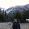
BC witness Posted February 5, 2024 Author Posted February 5, 2024 After several weeks of nasty weather, we finally got a nice weekend here in the Fraser Valley of BC, so I got out for a short field trip this afternoon. About 2 weeks ago, we got hit with a record one day snow fall of between 25 an40 cm (10 to 17in), followed by 10 days of rain and higher than normal temps, so I wanted to see how much snow was left in the local mountains. I met Thomas and Magni for lunch, but they had other plans for the rest of the day, so I headed to a nearby mountain for a careful solo run. I needn't have worried, since there were only very small patches of snow left in the shadiest spots. I reached the highest point of the logging road system on Murdo Mt., hitting only one 10 yard stretch of snow in the same spot where I was stranded for hours at this time last year. I scouted the little bit of snow, and every wet patch I came across for tracks, but found nothing at all. It was a nice sunny afternoon, but the wind was strong and cold at the peak, so my forays out of the truck were brief. The daylight is now lasting a little longer, so twilight came at about 5, and I headed home for supper. I finally got my computer to talk to my new phone, so I did get a few pics to show for the day. 1 1
BC witness Posted February 5, 2024 Author Posted February 5, 2024 @cmknight That's Stave Lake below in the 3rd photo; I'm above it on the east side.
cmknight Posted February 6, 2024 Posted February 6, 2024 15 hours ago, BC witness said: @cmknight That's Stave Lake below in the 3rd photo; I'm above it on the east side. Up Lost Creek FSR? That looks like the Stave River FSR in the distance there.
BC witness Posted February 6, 2024 Author Posted February 6, 2024 (edited) The photos are taken from Murdo Peak, accessed via Murdo Creek FSR, which branches from Lost Creek FSR at about km 2. It's the first drivable right turn from the main, and a very steep climb to the peak in 4km. There is a hiking trail to a small alpine lake (McKay Lake) from near the top of the road, on the Mt St Benedict trail, less than a km from the FSR. Edited February 6, 2024 by BC witness
cmknight Posted February 6, 2024 Posted February 6, 2024 I haven't been up that way, yet. I'll have to go before forest fire season hits, I guess.
BC witness Posted February 19, 2024 Author Posted February 19, 2024 I had a chance to get out for a few hours this afternoon, thanks to lengthening daylight hours, and chose to go to a long, high ridge that separates 2 of the larger lakes N. of the Fraser River. I first visited the farthest end of the ridge reachable by 4x4 with @cmknight about 5 years ago. The main FSR leading in was in great shape, thanks to ongoing logging, but the final few km beyond the work were very degraded due to water run off exposing lots of large broken rocks, just waiting to eat tires, so that section was very slow going. At the very end of the trail, I met a Toyota 4Runner with 5 university students who were new to the area, so I stopped and shared their campfire and chatted about the region for an hour or so, until near dusk, when we all decided to make the long run back to pavement before it got really dark. I stopped several places on the way in to check for spoor, but found nothing other than human and canine, and didn't spot any game at all. There is some sighting history in the area, including a well publicized hoax played on a group of Asian tourists a few years ago, that turned out to be a prank by a local ad agency to promote an adventure company. A small lake beside the road The narrow FSR at the logging site The large lake east of the ridge The large lake west of the ridge 1 1
cmknight Posted February 19, 2024 Posted February 19, 2024 @BC witness I haven't been back to that area since our last foray . How was that hill (near the end) with all of the loose shale?
BC witness Posted February 20, 2024 Author Posted February 20, 2024 Sorry for the late reply, cmknight, I was out on the west side of Harrison Lake with my son all day, and just got on the computer now. That rocky stretch seems to be even worse now, I took it really slow in the H3, with the tires aired down to 20psi. I certainly wouldn't take the Mitsubishi up there like I did last time. 1
BC witness Posted February 20, 2024 Author Posted February 20, 2024 Today, Monday, Feb. 19th, is the "Family Day" holiday here in BC, so I took my youngest boy, Rick, out for a trip on the west side of Harrison Lake. This area is where the word Sasquatch originated with the St'aillis people, with many legends of their encounters over the centuries, and many more recent sightings by loggers, prospectors, hunters, and campers. We spent the day exploring some of the many side trails off the St'aillis FSR, some leading to secluded coves along the lakeshore, just above sea level, and some high into the mountain ridges separating Harrison from the lakes and valleys to the west, reaching over 5000' in elevation. On one trail in particular we came across several little ponds and boggy areas nestled in the folds of the terrain that look to offer ideal conditions for foraging man-apes, with lots of cattails and berry bushes, dormant now, of course, but definitely worth another visit later in the season. We saw no tracks of big game or actual animals all day, but the weather co-operated with sun in the AM, some overcast in the later afternoon, and showers starting as we headed home at dusk. It was a very nice father/son outing, which we don't do nearly often enough. Rick skipping rocks at a tiny cove on the lakeshore. Looking south down the lake towards Cascade Peninsula. 1
norseman Posted February 20, 2024 Admin Posted February 20, 2024 8 hours ago, BC witness said: Today, Monday, Feb. 19th, is the "Family Day" holiday here in BC, so I took my youngest boy, Rick, out for a trip on the west side of Harrison Lake. This area is where the word Sasquatch originated with the St'aillis people, with many legends of their encounters over the centuries, and many more recent sightings by loggers, prospectors, hunters, and campers. We spent the day exploring some of the many side trails off the St'aillis FSR, some leading to secluded coves along the lakeshore, just above sea level, and some high into the mountain ridges separating Harrison from the lakes and valleys to the west, reaching over 5000' in elevation. On one trail in particular we came across several little ponds and boggy areas nestled in the folds of the terrain that look to offer ideal conditions for foraging man-apes, with lots of cattails and berry bushes, dormant now, of course, but definitely worth another visit later in the season. We saw no tracks of big game or actual animals all day, but the weather co-operated with sun in the AM, some overcast in the later afternoon, and showers starting as we headed home at dusk. It was a very nice father/son outing, which we don't do nearly often enough. Rick skipping rocks at a tiny cove on the lakeshore. Looking south down the lake towards Cascade Peninsula. You guys don’t have a lot of snow!
BC witness Posted February 20, 2024 Author Posted February 20, 2024 You're right about that! The local ski hills are all either closed or operating only the highest elevation runs. There is province wide concern about drought this coming year, with not enough snow pack to fill reservoirs in the spring.
BC witness Posted February 25, 2024 Author Posted February 25, 2024 I got a text from my buddy Bill (MagniAesir on here) on Friday asking our usual research group (Magni, Thomas, Alohacop, and myself) to meet up for an outing on Sunday morning, so of course I agreed immediately. At 0800 Sunday morning I arrived at the designated spot on Hwy 7, where we all gassed up and headed for the nearby watershed where I had my sighting many years ago. It was raining, but the forecast was for a break in the rain by about 0930. The weatherman LIED!! The rain intensified through the morning, so we continued to the end of the road system near the headwater lake, where there is a rough lean-to shelter where we could sit and talk for a while before calling it a day. By the time we were heading out, what had been small trickles of water down the rocks were now waterfalls, and in places some football size rocks had been washed down the hills onto the roadway. It was definitely time to get out of Dodge! It made for a short day, but we made plans for future trips later in the Spring. The convoy at the shelter. 2 new Rubicons and my 18 year old Hummer This creek is usually a trickle through a boulder field, now a gushing torrent Run off down what is normally a dry rock face 1 2
Recommended Posts