hiflier Posted July 11, 2019 Posted July 11, 2019 Thanks K. It seems that everywhere I've been out West the one thing that stands out is the millions of dead trees everywhere. I was shocked with what I saw when going through the Rock Mountain National Park last Fall.
NatFoot Posted July 11, 2019 Posted July 11, 2019 3 hours ago, hiflier said: Thanks K. It seems that everywhere I've been out West the one thing that stands out is the millions of dead trees everywhere. I was shocked with what I saw when going through the Rock Mountain National Park last Fall. That and the Forest fire damage. Blew my mind living out there and traveling around. Folks who live in the east have no idea. 1
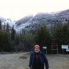
MIB Posted July 13, 2019 Admin Posted July 13, 2019 (edited) Fire damage? Did someone say fire damage? I had friday off work and planned to go backpacking. By the time I hit the trailhead, it was already quite hot and very buggy. Too hot for the bug jacket, too buggy not to wear it, so I punted. On the way back home I decided to fish a few places then got the idea to look for the lower end of an abandoned trail. One of my other (non-bigfoot) hobbies is retracing abandoned trails (with GPS) before they are lost to history. This is the fringe of an area shown on some maps as the "Oregon Desert". It burned in the 2017 Blanket Creek Fire which eventually wiped out over 30,000 acres. I was searching for the Dry Creek Trail, abandoned probably in the 1960s or 1970s, which had connected to the old Oregon Skyline Trail that was abandoned in favor of the then new Pacific Crest Trail in 1972. The PCT lies beyond the mountains in the background. The O-S-T began on this side and crossed over the saddle near the snow on the ridge. I found 2 boot tracks, very old, back in there. I also found one slightly larger track showing 5 toes. Both were pretty weathered. I never did find the trail. Dry Creek Trail was on my GPS and I went to the precise location where it showed, set a place mark, and came home. Turns out to be 0.2 miles from where I was able to locate the Dry Creek Trail visually from satellite maps. Don't trust your GPS too much. It will find specific locations if you have precise coordinates but the maps aren't that accurate. I can find a placemark I have set. I can't count on the accuracy of the maps to provide those precise coordinates. Anyway, yep, fire. We're getting big fires and they seem to be getting worse as things get drier each year and heavy timber weakened by drought becomes more susceptible to beetle-kill combining to make things more volatile than they've been in recorded history. MIB Edited July 13, 2019 by MIB 2
BigTreeWalker Posted July 14, 2019 Posted July 14, 2019 MIB Instead of using GPS, Google Earth and topo maps separately, one of the most useful apps I use constantly for doing just what you are trying to do is all-in-one OfflineMaps. I've found several locations by using this app to pinpoint a spot. There is a learning curve as with most things, but once you figure it out it is a useful tool. Maps can be downloaded when online then used when offline, which happens a lot in the country I frequent. I have and use the usual navigation tools for orienteering. But I use this to find special places of interest. I've used it to find places to put my cams in interesting spots I've located on Google Earth.
norseman Posted July 14, 2019 Admin Posted July 14, 2019 I love OnXhunt maps. https://www.onxmaps.com/
MIB Posted July 14, 2019 Admin Posted July 14, 2019 12 hours ago, BigTreeWalker said: MIB Instead of using GPS, Google Earth and topo maps separately, one of the most useful apps I use constantly for doing just what you are trying to do is all-in-one OfflineMaps. I've found several locations by using this app to pinpoint a spot. There is a learning curve as with most things, but once you figure it out it is a useful tool. Maps can be downloaded when online then used when offline, which happens a lot in the country I frequent. I have and use the usual navigation tools for orienteering. But I use this to find special places of interest. I've used it to find places to put my cams in interesting spots I've located on Google Earth. Thanks. Interesting idea. I don't have any issues locating spots with the GPS, the problem is the accuracy of the GPS maps. If I take coordinates off of Google Earth and create a waypoint on the GPS, I can get within 2-3 feet of the spot on the ground. So the issue Friday was that Garmin's map was wrong. I'm not sure there are better maps, I suspect what I'm doing is the best that can be done. I'm looking forward to returning to that area once the weather cools a bit. i'm going to do 2 things differently. First, I'm not leaving my canteen in the truck, second, I'm going to mark the truck's location so I'm not having to relocate it by dead reckoning again. MIB
BigTreeWalker Posted July 14, 2019 Posted July 14, 2019 In OfflineMaps it's all done at the same time. You find a spot, which you can mark. Then use the GPS in the app to get there. If you want to see terrain switch to topo. If you want to see what's there or forest cover switch to satellite. There's also a compass if your phone has that capability. Since it's all one program it works seemlessly.
Catmandoo Posted July 15, 2019 Posted July 15, 2019 (edited) On 7/13/2019 at 4:57 PM, MIB said: Fire damage? Did someone say fire damage? Did you say fire damage? Rattlesnake Creek fire damage from years ago. The images are just below Hart's Pass. The views are on the east side of the P-C-T. What is with the fires near the P-C-T ? I saw 1 deer in this area. Looking west, The P-C-T runs along the ridge in the background. The P-C-T crosses the road. There is a campground further up this road. Can't remember the name but it is a perfect telescope campground. Campsites are level and paved. Spendy, the pass to get through here was $80. I went past this area to prospect below Baron, on Slate Creek. This area is easy to find. Travel to Mazama WA., gas up, go west. The fire damage takes a long time to heal. Edited July 15, 2019 by Catmandoo more text
BigTreeWalker Posted July 15, 2019 Posted July 15, 2019 8 hours ago, Catmandoo said: Spendy, the pass to get through here was $80. Why the fee? Does it cross private property?
Catmandoo Posted July 15, 2019 Posted July 15, 2019 ^^^^ BigTreeWalker, I can't remember the permit. This was several years ago. I had to have one to get to Slate Creek for prospecting. I choked on the fee. Camping there has typical NFS campground fees currently. The road is one lane, mostly a cliff drop off. Scary.
BigTreeWalker Posted July 15, 2019 Posted July 15, 2019 21 minutes ago, Catmandoo said: ^^^^ BigTreeWalker, I can't remember the permit. This was several years ago. I had to have one to get to Slate Creek for prospecting. I choked on the fee. Camping there has typical NFS campground fees currently. The road is one lane, mostly a cliff drop off. Scary. Definitely looks like 'fun' driving. That is some rugged country. Nice thing about the NF is that you can camp wherever for 14 days for free. Unless specifically noted otherwise. In the GPNF they simply decommission the roads if they don't want you in there.
Catmandoo Posted July 16, 2019 Posted July 16, 2019 While trying to find info on permits and passes, I found the message that drones and unmanned aerial devices are not allowed in wilderness areas. Does not affect me but it's the 1st time that I have seen the 'no drone' message.
Twist Posted July 16, 2019 Posted July 16, 2019 I believe it’s due to disrupting wildlife especially tree dwelling and aerial creatures.
Recommended Posts