Leaderboard
Popular Content
Showing content with the highest reputation on 01/08/2020 in all areas
-
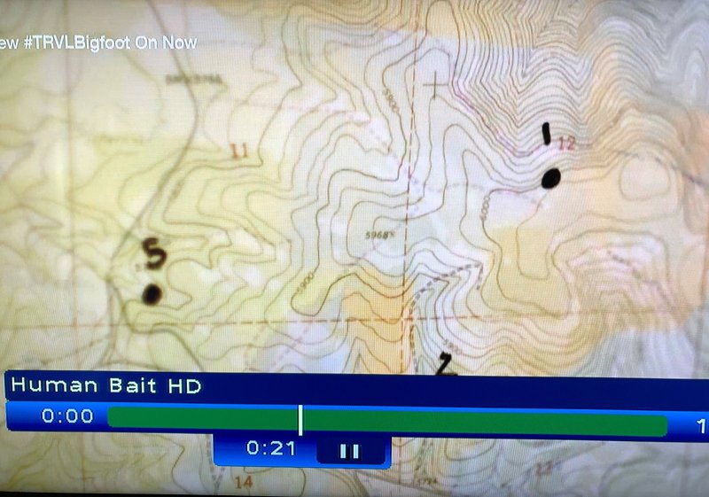
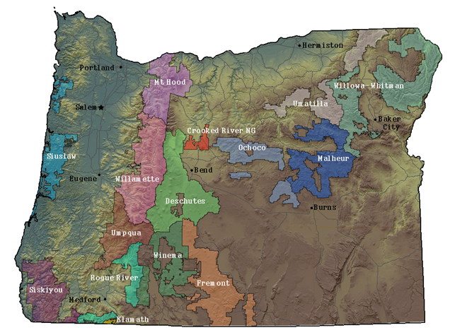
I took a photo of the topo map shown on Expedition Bigfoot Episode #5. This map was shown in about 21 minutes from start - including all the commercials. The photo I took is not very good but it shows some key map features: - peak at 5,968 ft between and below the 11 and 12 quadrant. - contour of 5,900 ft below this peak - tight contour lines on NE corner - the forest road on the west side going south to north I went thru my USGS topo maps for the targeted area around Ochoco NF (via my online Gaia GPS service) and looked for those 11 and 12 quadrants with that 5,968 ft peak. I found a place that could be a match (see attached topo extract). The coordinates for that peak are 44.45208, -119.92030. This is north of road NF-12 (also called Summit Road). However, I am not sure it this is the exact spot because when I look in Google earth around that area, I don't see places similar to what the expedition folks show on TV. Maybe it was a dummy map they used to illustrate the triangulation they were doing? Maybe folks here can better explore in Google Earth for a match around those coordinates.2 points
-
1 point
-
Shows like this are setup to fail from the get. At best they soften the general public to the idea of BF being a flesh and blood creature.1 point
-
You are really onto something that is rampant in bigfoot research. Most of the groups that have done organized research and searches start with the premiss that it is a big ape. Name many of the big names and they downplay the intelligence they are dealing with. If you start with a dumb animal premiss. you don't bother to camouflage game cameras, set simple bait stations, assume hunting tactics that works with deer, elk, and bear should work with bigfoot. Then are totally confounded when tactics do not seem to work with bigfoot and are unwilling to admit they are being outsmarted in the field. Because how could a big dumb ape, that cannot even weave baskets, or make a bow and arrow, outsmart them? I think that BF only exists now because it as a species has successfully and often avoided humans for many millennia. Human contact has not treated other bipedal competitors as well throughout mankind's history. As far as we know bigfoot is the only one still around.1 point
-
Google earth shows streams pretty well. While I do see green vegetation in the drainage patterns on Google earth, the July Google Earth image of the suspected area does not show any running water that I can see. I would think by August the area is devoid of surface water requiring BF to migrate just to drink. One of my conditions for likely BF habitat, is that running water is necessary year round. I have no evidence other than sighting report clusters which seem to cluster around running water. I honestly think they are smart enough to be pretty fussy about what they drink. There are some anachronisms in the episodes that have been presented so far. The most obvious one being trips to Meldrum at Idaho State presented as if they happened the same or the next day. It is quite a drive from Central Oregon to Eastern Idaho. That would be a minimum of a two day drive or airline connection. The deployment of sound detection equipment capable of determining the location was also presented as if it happened the next day. That is unlikely with any contractor involved. The show is a TV production first and foremost.1 point
-
Lol.....no "rangers", but there could be some hostile Indians. Were it me, I'd get a permit from the Port Graham village for a 3 or 4 day hike from Port Chatham to Rocky Bay. You wouldn't need to mouth the word "sasquatch"......unless you were planning a YouTube presentation, which I would definitely not be doing. Or, more likely, I'd do it like the folks in the video did: anchor in the gay and poke around the place for a few days. Or both, in two different trips. But, really, the last report I've heard of the place was in the mid-70's, some 55 years ago. But @ 50-75 miles by crew flight to the east, in Kenai Fiords National Park, Les Stroud had his experience not too many years ago. That area is truly remote. You won't see people in there. But you'll still need a permit.......this one from the "rangers". Stroud filmed a Survivorman episode in there without the permit, and the National Park Service rousted him up later and fined him several thousand dollars.......despite never having done so th o Timothy Treadwell, who they knew was in Katmai National Park screwing with the bears annually for 13 years. Go figure.........or just shoot yourself a sasquatch and trust your local ranger....1 point
-
I have a fairly inexpensive starter model parabolic coming in on Thursday. I will compare them to the headphones this weekend and let you know.1 point
-
Yeah, but I am sure that everyone here has seen a vehicle that has hit a deer. There is blood, tissue, and fur left on the vehicle. What is happening to THAT evidence? Are the MIB washing the car before they leave with the body? Impounding the vehicles?1 point
-
Looks like beautiful country Norse and love the setup on your truck that you displayed built/launched earlier this year.1 point
-
I do? Different facial hair maybe? I do like that area around Lake Ellen/White mtn. Above freezing and melting. Not a researcher... just a hunter.1 point
-
Great find, Explorer! It's either a dummy map, or the producers think they're playing to a dummy audience. I suspect it's the latter........1 point
-
1 point
-
Behind Lake Ellen today. Lake is froze over but it was 34 degrees today and wet snow. Out of 3 batteries on my drone only one worked. Got about 20-30 min of flight footage. The new drone rules are dumb. It has a 350 ft ceiling. It takes into account the take off point elevation. So flying up the mtn I was running out of airspace! Need to launch from the highest point available. Saw deer, moose, rabbit tracks was it. Would love to find some Moose sheds! Checked out the “swamp” were the skunk cabbage grows in spring. Nada.1 point
-
Welcome to the BFF SoldierLife, Sandra, and RobH; glad to have each of you as members!!! Welcome back to the BFF DuneBeast, hope you find it as interesting as the first time around.1 point
-
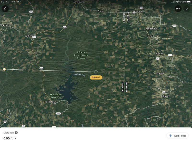
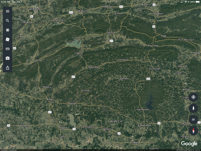
Their leader Brian once owned this forum! Just a bit of trivia! I love Kathy. She still helps run this forum as the SC chair. I wish em the best of luck. But I prefer to stay here in the PacNW. I’m guessing areaX resides somewhere in that untouched game reserve. Its fairly close to Honobia. And Antlers where recently Mark has been having problems on his property. First pic is zoomed in and a ruler pulled for distance reference. The second is zoomed out to show the outlying towns.1 point
-
My experience with a equipment malfunction while out searching an area was my camcorder. To this day I have no explanation for it. We found a set of tracks that were very clear and were no older than a day. Could even have been the same day just hours old.I had my camcorder on the whole time while I was out so it was never turned off except hours later when we stopped for lunch and rest a bit I installed a new battery pack. Seconds before we find the tracks I am filming and taking to my friend who's with me. I then say hey look at these and we spend a half hour or so in the spot filming the prints and talking about them. When I get home i pull out the SD card to watch the video . I like to watch the whole thing because I'm always scanning the camcorder in case it films something in the forest I miss to see. Well seconds before it gets to the part in the film when we found the tracks and I say Hey look at these the picture goes black . You can hear us talking about the tracks but there's no picture . Then when we are leaving the picture on the SD card goes back to filming as I'm watching it on my lap top . I have no explanation for it.1 point
-
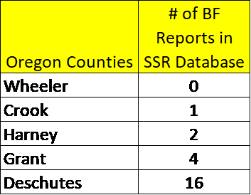
BobbyO, They did report (not in the show but in other articles) that they were near the vicinity of the Ochoco National Forest,. That is why I posted the stats above earlier. My guess is that when they say that they used an algorithm to find the best location to investigate BFs, that does not imply to be using BF reports per se. They might be using other parameters that they think correlate with BF habitat - like food availability (deer, elk, berries, etc), water availability (creeks, rivers, lakes), vegetation type (old growth forests, etc.), snow level in winter and spring, etc and generate an index of BF habitat per time of year in a US GIS map. That could explain why the SSR stats does not find this location worthy of investigation, but other correlates might. Explorer1 point
-
1 point
-
I was a little surprised they took that feature away just because some people got upset about being downvoted. I post what I believe, some agree and some do not. They may choose to express their opposite opinion with a downvote or let it be known via a post. Either way there is nothing wrong with disagreeing, adversity is good in an unknown field. I can agree with a poster 100% in a topic about eye shine and then disagree with them 100% in regards to BF population. Doesn't make them my best friend or my enemy in either situation. It just shows we are two individuals forming differing or similar opinions on a shared subject. The only certainty in BF is uncertainty at this point.1 point
-
1 point
This leaderboard is set to New York/GMT-05:00

