Leaderboard
Popular Content
Showing content with the highest reputation on 11/15/2020 in all areas
-
The most funny part is that for so many russian people Siberia as far away as an Alaska! But here we have so many regions with activity, including Moscow suburbs. So, no need to go far!2 points
-
We got out to the edge of the 100 Mile Wilderness today for a hike up to a 2000' mountain with some beautiful views but no signs of any anomalous critters. It's nice older growth forest which has not been cut in over 100 years. (There is a new class b incident report from mid October about 45 miles away for the crow. Coincidentally, it is in exactly the same area I was eying up for a recon 2 weeks ago.) Saw 2 red fox, the first curled up roadside and apparently injured but we watched it trot off with a slight limp and quickly catch and eat something in a field--looks as if it'll manage. Passing one of the 3 ponds on the way up: Distant sunbeamed obvious older cut: From the summit: Some great light and scattered snow from last night:2 points
-
1 point
-
1 point
-
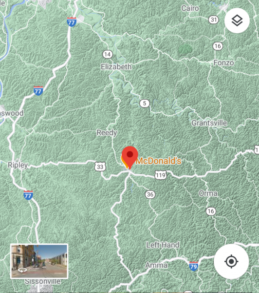
Starting this coming Saturday I'll spend about 5 straight days in the woods of Roane County, WV with a buck, doe and black bear stamp and my .30-06. Camp has no electricity (gas only) and we aren't planning to come out for our time there unless we all tag out. There's three of us on 300 acres and I was told to buy the bear tag because I'm almost certain to see a black bear on the property. Ok, @gigantor and @BobbyO....hit me with the sighting maps which will keep me on my toes the entire time I'm in the woods (even moreso than if I was just hunting whitetails). Spencer is the closest town with a Walmart and centered on the map below.1 point
-
Tad easier to see on gigantors post. Not sure it looks like a cat though...or a rabbit. But it's something with legs.1 point
-
Darn Tough socks are all that I wear anymore. They are great! I'm saving up for a FLIR.1 point
-
My buddy Robert has uploaded the 2 drone flights from last Sunday's trip up the Anderson and East Anderson Rivers. I admire his skill and endurance in piloting these flights, as the wind was blowing quite strongly, and the temperature was -2C. My face and hands were numb by the time he landed each time. In the first video, you'll notice the difference in speed, into the wind outbound, and with the wind returning.1 point
-
1 point
-
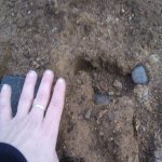
We just got in from checking out our current spot. Called it a night relatively early, since we both suddenly and unexpectedly ran out of steam. No photos until we review IR footage tommorow. No current activity either, although we did find a couple of pretty decent prints along with quite a few partials. We actually saw our first deer up there after being in that area for several weeks now. We found the prints along an old logging road that the forest has reclaimed. There were a few drag marks along the path and we found a clump of deer hair on a sharp part of a tree that had fallen across the path. There were traces of what looked like boot prints, but they looked mostly wiped away by the drag marks. The 15" bare footprints had obviously occurred after the drag marks. My initial impression was that someone got a deer up there, drug it through of the woods, and whatever made the large bare footprints followed them out. Maybe they followed the scent of the deer... although that is certainly conjecture on my part. Those might not have even been boot prints, as they had been obscured by whatever had been dragged along the forest floor. During a daytime scouting mission we ran into a guy who said that he came up there to 'hunt', which basically means to come out there and drink beer in a tree stand all day long since there are no deer and as a result no other hunters around. There are at least a couple of deer up there, as we saw one tonight. However, this region is crawling with deer right now. It's strange that such a secluded area with ample food and water is barren of deer. If there are any hunters, then they are very few and far between. We saw the usual hunter detritus in one clearing at the base of the mountain, but the higher elevations are clear of the usual beer cans and whatnot. In addition to the prints, we found quite a few X shaped tree 'structures' surrounding a bowl shaped little valley that is pretty well hidden up there. I have never been a proponent of tree structures, since I always believed that they were the product of a mixture of overactive imaginations, a desperate desire for Bigfoot activity, and the randomness of the forest. However, I only ever see these X shaped tree bends/breaks in this one area. Following the path that I believed that the prints that I mentioned above took, we saw the first giant X right above where the tracks entered the treeline. It might have been the product of coincidence, but it jumped out at me immediately. You had to walk beneath it to follow the trail. Needless to say, I am re-evaluating my position in tree structures. Like most of my other preconceived notions, my feelings on structures may have to change. I can't deny that there is a pattern there. Of what, I don't know. As with anything, if you don't actually see it being made then you can't really definitively say what made it...if it was even 'made' at all.1 point
-
Wonderful hike and wonderful photos. All that water and forest makes for prime habitat. Now I'll google 100 Mile Wilderness :-)1 point
-
1 point
-
@BlackRockBigfoot & @Kiwakwe, it's great that you both got out into some very interesting territory, and thanks for the great pics. I got away for a full day today, with my daughter Andrea and Robert J., to the Anderson River watershed, a tributary of the Fraser River. It's quite a bit further than my other recent outings, so we were out the door at 5AM to get to the area at sun up, making for a long day. We first went off pavement at a logging road just beyond the Alexandra Bridge, which took us in to the west branch of the river, towards a sighting from 1997 which is well documented by Thomas Steenburg as the Mike McDonald sighting. We were able to find the spot thanks to the description in the report, and Thomas' previous trip there with Robert a few weeks ago. The trail from which Mike saw the Sasquatch across the river is now quite overgrown, so our short hike to the actual spot required some scrambling and bushwhacking, but was worth the effort to see the area, and visually confirm his report of the circumstances. By the time we got back to our vehicles, we were happy to climb in and crank up the heaters, as the day was quite cold, -2C, in spite of the clear blue skies. We continued a few more km along the now narrow power line trail, till we found ourselves looking into a deep canyon, where the east fork of the Anderson flows in from the south. There was a road visible below us on the other side of the canyon, but no connection to it that we could find from our side, in spite of the fact that Robert's Back Road Map Book for the region showed a route there. That book did show another road off the main highway into the East Anderson, so we backtracked 30km to HWY 1, headed east to the outskirts of the village of Boston Bar, and found that road. A few km in, we found a nice pull out on the side of the logging road, sheltered from the cold wind, and stopped for lunch. Rested and re-energized, we continued up that road to eventually reach a locked gate about 25 km in. Along the way, we saw 1 grouse, which flew off before I could get my 20G breakopen loaded, and 2 different black bears, one large one that Robert saw, while I drove right by, and another a couple of km further along, that bolted down the road and over a steep bank towards the river. Finally, at was nearing dusk, and it was time to head home. Robert once again got some drone footage of both the West And East forks of the Anderson, and will post them up once he gets them uploaded. I have a few of my usual phone shots: East fork of the Anderson Late afternoon on the way out A roadside waterfall turning to ice!1 point
-
1 point
-
That looks very much like the Peace River area of NE B.C. and NW Alberta. The vegetation, tea coloured water, and iffy roads are just like that.1 point
This leaderboard is set to New York/GMT-05:00



.jpg.b5c8420ce01458630cf89afd9b1fd29c.thumb.jpg.08a17e7147aee99ef1824b1f4b9a5c70.jpg)
